
Hey Readers,
Check out this beauty that I’ve spotted on Intellicast CONUS North American radar.
The link is here http://www.intellicast.com
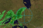
The radius on this one is huge, over a hundred kilometers in diameter. As the screenshots will show there is a lot of rain activity going on specifically in the region of the ring itself. I’ve drawn a circle around the outer edge of the ring so that I could locate the center of the circle. DutchSince the now-famous weather blogger has maintained from the beginning that most of the time he finds airports and/or military bases at the center of these anomalous radar pings. He calls them HAARP rings based on the US Military experiment/base in Alaska going by the same name.
What does HAARP stand for? High Frequency Active Auroral Research Program
Anyways, what did I find at the center of this ring? A town. A place that has the moniker “The Model Town of the North” that’s right it’s Kapuskasing, Ontario. Strangely enough the google map image directly over this town is awful and I mean awful by Google standards. Plus, there is no street view action in the entire town – not joking. Are you trying to tell me that the town that bills itself as the ‘model’ town has escaped Google’s attention in the most populous province in the country?! It seems outrageous that the municipal officials would let this happen. In the meantime, they have a nice small-medium airport right in town and it’s even located on Government Road. As I said the image quality is degraded so badly that I can’t make out specific objects at the airport which makes it virtually impossible to locate a radar tower. But there it is anyways, an immaculate coincidence perhaps.


Cheers
J

hmmm… maybe you find airports and military bases at the centre of these rings because it’s there the radar are located, and you just witness radar analogue to digital conversion glitches ?
a radar has a view in a ring around it and the map is composed of multiple radars signals combined. If one miss the global map appears with a ring shaped glitch… it’s quite straightforward.
onemiss, everything you’ve said sounds fairly reasonable but I think that
the evidence of my own personal research suggests more than the obvious.
I’m not saying your points aren’t valid, I am saying that you should start
a blog dedicated to posting screenshots of any “radar analogue to digital
conversion glitches” & similar and I will do an unbiased comparison.
Unfortunately, http://sincedutch.wordpress.com has a no-joke track record in
forecasting awful weather events in the lower 48 states. I’ve personally
studied the subjects of scalar energy, longitudinal waves & energy from
the vacuum for over 10 years. This allowed me to recognize that in in the
bare minimum; I knew that the energy science Dutch “claimed” to be basing
his assertions upon was (is) indeed real. Plus there’s more than just
circles going on, there are square shapes too. They overlap each other in
some cases to cause a particular series of reactions in the sky (or the ground).
The use of longitudinal waves to affect weather has been going on for nearly
a century but they have been heavily tested in North America since the late 70’s.
Skepticism is healthy, but good research is more important. Allow me to leave
you with this quote from a 1997 briefing given by then US Secretary of Defense,
William Cohen “Others (terrorists) are engaging even in an eco type of terrorism
whereby they can alter the climate, set off earthquakes, volcanoes remotely
through the use of electromagnetic waves… So, there are plenty of ingenious
minds out there that are at work finding ways in which they can wreak terror
upon other nations… It’s real, and that’s the reason why we have to intensify
our (counter-terrorism) efforts.”
I was going to post the exact same thing (radar is circular, each radial slice consists of multiple power levels for different ranges, if the calibration is off the baseline noise of each power level makes it look like a “smoke ring” of return bounce when there isn’t actually one, uncalibrated non-linearity in the signal can cause “ripples” attributable to the phased-array steering that uses multiple fixed antennae to sweep an angle), but realized that no actual fact will have any effect on these people.
Now back to reality and actually doing something productive.